Archive

Fuji X100 digital

DSCF5384-3

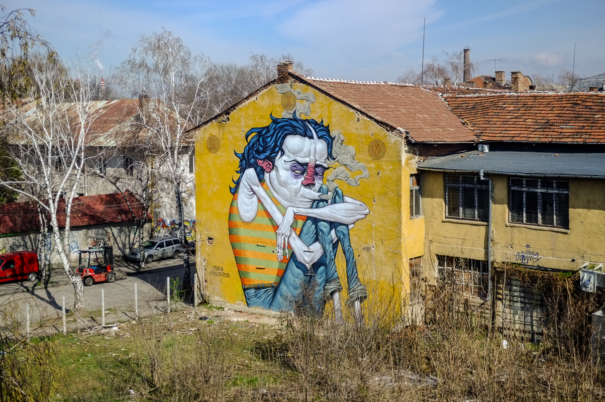
Mural, housing block, Hadji Dimitar quarter, Sofia, Bulgaria, 2016. Fuji X100 with +1.4 lens adaptor. Click on image to enlarge.

Further to a previous entry on the presence (and, to me, mystery) of a spate of apartment-building-height murals, psychedelic in style and puzzling in content, in the adjacent Sofia neighborhoods of Poduyane and Hadji Dimitar, I’ve posted a photo of a third such mural above.

I’ve selected the photo not just for its bizarreness and whimsicality nor for the issues it raises as to the ownership and aesthetics of the public realm.  Rather, a close examination of the building on which the mural is painted summarizes a full set of urban issues which I have been researching, conceptualizing, and visually portraying over the past months and into which — ideas for grant support, anyone?!? — I intend to delve further in the time to come.

Specifically, note the balconies on the right-hand face of the building, some open as per their original design and others closed-in to expand private space.  Balconies, as I hope to explain in subsequent posts, are interstices between public and private space, and Sofia is a city of balconies. How balconies are, or are not, used reveals much about the history of and changes in social and politic environments and individual responses thereto.

Also note the monochrome, but vaguely Mondriaan-like, effect on the walls of the building in the photo above, an effect more pronounced in the photo that I’ve added below. The question of why such buildings have been insulated apartment-by-apartment rather than building-by-building, and what this tells us about societies and governments, is one that I have also been examining and visually documenting of late.  Although the aesthetic effect of uncoordinated action by apartment owners on their own relieves monotony and adds color to the public realm, devolution to the individual apartment owners is the most inefficient and inequitable means of preserving public health and comfort and of cutting heat-loss through building envelops, possibly the most weighty contributor to energy consumption/inefficiency in the built environment.  Hopefully, more on this as well.

Poduyane quarter, Sofia, Bulgaria, 2016. Fuji X100 w/ +1.4 lens adaptor. The uncoordinated color schemes of privately insulated apartments on the facade lends an accidental Mondriaan-like counterpoint to the neo-psychedelica of the mural on the lateral face of the building.

Poduyane quarter, Sofia, Bulgaria, 2016. Fuji X100 w/ +1.4 lens adaptor. The uncoordinated color schemes of private insulated apartments on the facade lends an accidental Mondriaan-like counterpoint to the neo-psychedelica of the mural on the building’s lateral face.

Mural, warehouse, Poduyane quarter, Sofia, Bulgaria, 2016. FujiX100 w/1.4x tele converter. Click on image to enlarge.

Mural, warehouse, Poduyane quarter, Sofia, Bulgaria, 2016. FujiX100 w/1.4x tele converter. Click on image to enlarge.

I have no nostalgia for the 1960’s. I was not a hippy. I liked jazz and R&B; indeed, white rock music seemed to work counter to my biorhythms. I was into the labor, civil rights, and antiwar movements and couldn’t comprehend psychedelica.  I looked and felt ridiculous in bell-bottomed,”hip-hugger” trousers and “love-beads,” and — alas! — I didn’t “ball” at Woodstock.  The rise of graffiti in the 1970’s also left me cold.  For many of us native to the “inner city,” the proliferation of graffiti was an added degradation and a upsetting sign of social atomization and the break-up of consensus, an aggressive imposition without consent onto the visual fields of the many by the out-sized and aggressive egos of a few, and a notice of abandonment by those outsized-ly enfranchised, economically and politically, and at a safe remove from urban grit.

Nevertheless, I smile at the murals portrayed in the photos above and below, two among several that have appeared recently in the working-class quarter of Poduyane in Sofia, Bulgaria.  The murals add a touch of brightness, whimsicality, and edge — I just hope that they were done with the participation and consent of neighborhood residents!*  Not least, the murals pose at least one iconographic improvement:  A few years ago, the only apartment-block-height “artwork” adorning building exteriors in Poduyane and the neighboring quarter of Hadji Dimitar were giant banners silk-screened with the smug, scowling face of the pint-sized leader of Ataka, Bulgaria’s  disturbingly popular antisemitic, anti-Gypsy, anti-Muslim, neo-fascist political party. Give me psychedelica any day!

* If any of you who happen upon this site know something about who did the murals and/or how they were conceived, approved, implemented, and received, please get in touch.

Mural, apartment block, Podyane quarter, Sofia, Bulgaria, 2016. FujiX100 w/1.4x wide-angle converter. Click on image to enlarge.

Mural, apartment block, Poduyane quarter, Sofia, Bulgaria, 2016. FujiX100 w/1.4x wide-angle converter. Click on image to enlarge.

DSCF1951-2

Mannequins in Black and White, Istanbul, 2013. Fuji X100.

The image above is from a series of photos treating mannequins in Istanbul, their manufacture and display, part of an in-depth look into the urban geography of a traditional sector.  Mannequins, as I discovered, are designed and produced according to a complex web of typology and hierarchy — price-wise and according to the class, incomes, tastes, beliefs, cultures, and aspirations of the “markets” targeted to purchase the garments in which the mannequins will be clad.  In a future entry, I hope to post more photos from the series and comment further.

Saturday’s bomb attack

For now, in light of the murderous bomb attack this past Saturday on Istanbul’s main pedestrian thoroughfare, Istiklal Caddesi, I am posting this photo as an all-too-obvious metaphor for the dualiities and contradictions that enrich but also plague Istanbul — its peace and its violence, its tolerance and its hatreds, its physical location straddling two continents, and its seeming temporal spanning of the world views of multiple centuries.

Metaphor

The black-white duality of the mannequins’ garb also suggests the extremes of Istanbul’s and Turkey’s ruling AK Party and its leader Recip Tayyip Erdogan — a propensity towards confrontation, bluster, and intimidation that yields and masks a polarized polity at home, failed ambitions in the middle east, failed outreaches towards the west, and dual failures in dealing with complex conundrums of Syria and predominantly Kurdish eastern Anatolia.

Black-white contrasts also characterize the history and transformation of Istiklal Caddesi and surroundings. In Ottoman centuries Istiklal was a street of palatial Ottoman homes and western embassies and, by the early- to mid- twentieth century, a western-style avenue of shops, cinemas and entertainment, with backstreets sheltering tenement housing and offering drink, music, and food, as well as bordellos, “straight” and transvestite.

In recent years, Istiklal continues to change, becoming less and less upscale on the one hand, and less local and bohemian on the other, and more and more like an open air shopping mall, with rising rents forcing out independent merchants and restaurateurs in favor of chain operations with deep pockets and with historic buildings gutted, their restored facades masking modern shopping emporiums.  In the backstreets, “vice” and seediness fade and “cute” coffee shops take their place. The flow of pedestrians, locals and tourists, up and down Istiklal increases each year, with the noticeable changes that the crowds seem progressively younger and the tourists as often as not (mid-)eastern as western.

Even in the midst of such changes, Istiklal remains the site of political demonstrations and of symbolic acts, both democratic in aspiration, ala the summer of 2013 (scroll through the following group of posts) and, tragically, murderously anarchic as per Saturday.

The black-white metaphor also points to another of the city’s contradictions.  Istanbul is marketed as “multicultural” and “tolerant,” but the reality plays out otherwise.  Few Istanbul Greeks remain in the city, its Armenian population stagnates, and its Jewish population ages and declines year by year as younger Jews leave for abroad. What remain of all three of the city’s traditional minority populations have moved to the comfort, anonymity, and security of neighborhoods far afield from the surroundings of Istiklal.

Irony

By chance, three of the victims of Saturday’s bombing were Israelis and the attack took place within fifteen minute’s walk of the lower reaches of Istiklal, the neighborhood of Galata which, a century ago, had been home to a large Jewish population and that still houses three of Istanbul’s regularly-functioning synagogues.  The three synagogues operate under extreme security, precisely due to eventualities such as Saturday’s attack — indeed, one of the synagogues was bombed fifteen years ago and attacked by machine gun and hand grenade wielding murderers fifteen years before that.  Ironically, at the time of Saturday’s attack, the visiting Israelis would have been far safer attending one of the nearby synagogues than enjoying the sybaritic luxury of a peaceful Saturday morning stroll on Istiklal.  This too is amongst the contradictions and ironies of Istanbul.

Street View, Kurtuluş, Istanbul, 2012.  Fuji X100. Click to enlarge

Street View, Kurtuluş, Istanbul, 2012. Fuji X100. Click to enlarge

Three photos of three structures linked by geography and revealing facets of the dynamics that have shaped Istanbul: The row of apartment houses shown above stands on the crest of a ridge; the church and the construction site portrayed in the images below are set in the deep valleys that wrap around its lower reaches.

Tatavla

The apartment house row is located in Tatavla (present-day Kurtuluş) near the quarter of Bomonti, neighborhoods once largely Greek and still, in part, populated by Armenians and Jews.  Tatavla was  redeveloped at the turn of the nineteenth to the twentieth century when “minorities” of modest income began to move out of cramped housing in the Galata and Pera and the slopes below them and resettle in newly built dwellings in the heights beyond Taksim. The uniformly narrow frontal widths of building plots were determined by fire laws of the time in combination the economics of low cost housing.  Building facades have been refurbished over and again as the decades passed, creating a stark geometry of plasterwork and stone.  The streets are as prim and as quiet as they are treeless.

_DSF2298-3

Facade, Evangalikos (Panagias Evangelista) Church, Dolapdere, Istanbul, 2012. Fuji X100. Click to enlarge.

Evangelikos

The church facade above is that of the Greek Orthodox Church of the Evangelikos (Panagia Evangelista), a huge eclectic structure combining a domed cruciform neo-Byzantine sanctuary with a neo-Gothic facade, a combination perhaps symbolic of the self-styled Byzantine roots and European aspirations  of the community that built it nearly a century and a quarter ago.  The Church of the Evangelikos stands in the valley of Dolapdere, one block from what is now a major traffic thoroughfare.  Until recently, Dolapdere Boulevard was a rough and tumble street, by day home to automobile repair shops and ateliers producing window display mannequins and by night seemingly deserted and legendarily nefarious.  Pedestrian traffic on Dolapdere is light but motor traffic is heavy and fast, and the church, half obscured by shabby storefronts fronting on the boulevard, is usually seen only in a mere flash from the windows of passing cars.

My guess is that the location of the Church of the Evangelikos was determined by two factors.  First, like many Eastern Orthodox church locations, it was built adjacent to an ayazma, a sacred natural spring.  Such streams have been holy to pagans and to Christians and to heterodox Muslims and dervishes as well, and have determined the sites of many other churches and one-time dervish monasteries throughout Istanbul.  The second locational factor may have been more mundane but no less universal — cost.  In inland parts of Istanbul, real estate prices traditionally are higher atop breezy crests and the upper reaches of slopes than in the less-well-ventilated, vista-less confines of valleys and former riverbeds .(Note: this rule is reversed at in the city’s coastal locations, where sea breezes and waterfront access and vistas have long commanded premium prices.)

P1010267-6

Construction site preparation, Bomonti / Piyale Paşa, Istanbul, 2013.  Panasonic LX3. Click on image to enlarge.

Bomonti to Piyale Paşa below

The construction site pictured in the last of the three photos links back to a story I posted a year ago reflecting on development in Istanbul and the politics and values of hillside locations and views.  At the time, the newly built middle-class dwellings in the upper reaches of the photo enjoyed views unobstructed by the shanty town below.  In the present photo (taken in 2013), the shanty-town dwellings have vanished and site preparation materials for new blocks of flatsare laid out in artful cascading swirls.  By 2014, the new flats were in place, leaving windows and balconies of the blue block shrouded in perpetual shadow, their views limited to the rear walls and windows of the newer buildings in front of them, from which they are now separated by a street of only medievally narrow width.  In urban contexts, views and vistas are ephemeral and limited in time and reach, this is even more so the more modest one’s means and apartment.

Main entrance section of the original building of Or Ahayim Hastanesi, the Balat Jewish Hospital, Balat, Istanbul, 2013.  Inscriptions, extent and obliterated, on its facade give insight into realities of past and present-day Istanbul.  (Fuji X100) Click on image to enlarge.

Main entrance section of the original building of Or Ahayim Hastanesi, the Balat Jewish Hospital, Balat, Istanbul, 2011. Inscriptions — both extent and obliterated — on its facade give insight into realities of past and present-day Istanbul. (Fuji X100) Click on image to enlarge.

The Or Ahayim Jewish hospital in Balat was founded and built in the last decades of the 19th century.  Its construction and original endowment was funded by large donations from wealthy Istanbul Jewish families, as well as by masses of small coins placed into collection boxes by Istanbul’s far more numerous Jewish working poor.   The monumental former entrance way as shown above, built in 1898 to replace an earlier structure, was designed by Architect Gabriel Tedeschi who, if I am correct, was also the architect of the Ashkenazic Synagogue (built as the Austro-Hungarian Synagogue) near the Galata Tower on Yüksek Kaldιrιm in the Karakoy section of Istanbul.  Today, Or Ahayim complex comprises the only buildings in Balat still standing on the shore side of the Golden Horn coastal road, on what is now a park but was once the site of a shore-front slum.

A Shining Light

The Hebrew name “Or Ahayim” literally translates as “Light of Life” — and a true light of life the hospital has been and remains to be for Jews, Christians, and Muslims alike.  Originally founded as a dispensary for the Jewish poor, the hospital, still funded and administrated by the Jewish community of Turkey, now serves the almost completely Muslim population of Balat, a sign of the commitment of Istanbul Jews to the city in which they live and have been rooted since early-Ottoman times and, in the cases of those who can claim Romaniote origins, far longer.

Cautious Discretion or Imposed Anonymity?

In the face of realities of contemporary Istanbul, the identity and history of Or Ahayim, like those of many other “minority” institutions, seems discreetly obscured.  The “history” page of the hospital’s website never directly mentions the institution’s specifically Jewish identity but subtly suggests such by listing the characteristically Sephardic- (and, in one case, Ashkenazic-) Jewish family names of the original founders and donors, including, amongst others: Dalmediko, de Kastro, Gerson, Molho, Halfon, Levi, Kohen, and Grayver.  Some of the donors named held military titles, including one physician with the naval rank of Admiral, others held the honorific of “pasha.” My own favorite amongst the names listed is that of Yuda Levi Kebapçıoğlu — kebapçıoğlu meaning “son of the kabob vendor,” an honorific seemingly rooted in hard work and, in culinary terms, more to my own taste.  Likewise, the website mentions that the hospital housed refugees that arrived in Istanbul from Russia in the 1920s and Poland in the 1930s but similarly sidesteps any mentions of their ethnicities.

The facade of the hospital also displays a ambiguous blurring over of identity.  A very large Hebrew letter inscription in the central panel of the architrave at the apex of the structure, formerly visible from afar, was plastered over late sometime late in the last decade (according to my memory either soon after disturbances in the aftermath of the Israeli incursion into Gaza or the Mavi Marmara affair).  Vague traces of the inscription can be seen in the full sized raw file of the photo above, my reading thereof being the Hebrew words “Beit HaHolim Or Hayim” (Or Ahayim Hospital). Somewhere in my archives, I have a photo taken early in 2008 in which the inscription was still clearly legible. Oddly, a similar blurring over of the inscription is shown on the ostensibly vintage illustrations on the hospital’s website.  Two other inscriptions near ground-level, both less obvious to passersby, still proclaim the origin and  identity of the building: Over the main doorway, in Latin characters, the words “Musevi Hastanesi” (Jewish Hospital) and, on a small plaque tucked away at the lower left corner of the facade, in Hebrew characters but in Ladino (Judeo-Spanish, the former language of the Jews of Istanbul) the inscription “Ispital Or HaHayim” followed by the Gregorian date 1898 and its Hebrew calendar equivalent, 5658.

Erasure of Urbanity

Erasure and obliteration of Hebrew inscriptions, six-pointed stars, and building construction dates according to the Jewish calendar from communal structures and residences originally built by Jews has been a feature of renovations and gentrification of quarters of Istanbul including Galata and Kuzguncuk.  Whether intentional or out of ignorance, such erasures dovetail with the present-day rejection of the past urbanity of Istanbul as well as with the reformulation of identity and history in a self-styled, and thus increasingly, homogeneous and mono-religious Turkey.


Balat, Istanbul, late-afternoon, December 2011. Fuji X100. Click on image to enlarge.

Late afternoon light. Balat, Istanbul, December, 2011. Fuji X100. Click on image to enlarge.

The birthday last month of a friend with a sharp and compassionate eye for the poignancy and ironies of urban details provided an impetus for me to cull the archives and print images including the ones above and below, both taken late afternoon some years ago in the quarter of Balat on the shore of the Golden Horn, Istanbul.

Changing Populations

For centuries, Balat and surroundings had been home to Jews, Armenians, and Greeks.  From the 1940s on, these “minority” populations, both of Balat, and of adjacent, once mostly-Greek, Fener, the seat of the Orthodox Patriarchate, plummeted.  Traditional occupations, including those of Jews as boatmen and stevedores in Istanbul’s once-nearby port facilities (which, during the mid-20th century, in search of ample space, shifted outwards towards the urban edge) faded away, contributing to the departure of poorer Jews for Israel and better-off ones to newer neighborhoods north of Taksim Square, along the upper shores of the Bosporus, and on Istanbul’s Asian side.  Armenians followed similar patterns of migration within the city.  Greeks were pressured to leave Balat, Fener, and, for that matter, all of Istanbul en masse following the anti-minority riots of the mid-1950s and a series of expulsions and seizures of property thereafter. By the 1960s and 1970s, Balat became the province of a new wave of residents, emigrants from towns and villages in north and central Anatolia.

Recently, the population of the quarter has begun to change again.   Neighborhood ties have loosened and descendants of the new arrivals of two and three generations ago seek better housing elsewhere.   Developers have razed older structures at the northern edge of Balat and begun to build modern, higher-priced ones in their place.  Refugees from Syria, Arabs, Turkmen, and Kurds, monied and poor, have found homes in the Balat’s still ample stock of dilapidated housing.   The very same housing supply provides a magnet attracting a first wave of gentrifiers with tastes for traditional housing near the urban core and with sufficient financial resources to purchase and renovate individual apartments or entire buildings.  Their presence is signaled by the openings of antiques stores and espresso bars.  Their arrivals and the arrivals of those in their footsteps cause local real estate prices to skyrocket.

Afternoon Light and Shadows

As some buildings are razed and others renovated, as established locals depart, and as gentrifiers pursue their dreams of authenticity and refugees build new lives in the face of uncertainties, memories and echoes of those who lived in Balat long before  them vanish.   Decades of newer residents walk past shuttered synagogues, underused churches, and Jewish and Christian communal buildings only peripherally conscious of what was once central to the lives of those who they replaced.  One thing still remains constant, however … the afternoon light, ricocheting off the facades of Balat’s east-west streets and shrouding its north-south ones in shadows.

Row Houses, Balat, Istanbul. Late afternoon, December, 2011.  The nameplate of a Jewish physician on the entrance-way of one of the houses is one of the rare signs of the remaining presence of Jews in the buildings of what was once one of Istanbul's most densely populated Jewish neighborhood.

Late afternoon shadows, row houses, Balat, Istanbul, December, 2011. The nameplate of a Jewish physician on the entrance-way of one of the houses shown  is a of the rare signs of the remaining presence of Jews in the buildings of what was once one of Istanbul’s most densely populated Jewish neighborhood. Click on image to enlarge.

Rowhouses and Sea Walls Saved by … Automobiles!

Six or seven years ago, I joined a friend/colleague from the architectural department of one of Istanbul’s universities to trace the remainders of Byzantine and Ottoman sea walls in the court yards and backstreets of Balat closest to the water’s edge.  Over the centuries, progressive silting, intentional landfill, and the construction of a shore line roadway and green space had stranded extant fragments seawalls a few hundred meters inland.  The purpose of our survey was to ensure that historic seawall fragments would remain untouched in the face of a proposed real estate development project that would transform rows of houses, like those below, into upscale townhouses by restoring their facings but fully gutting, enlarging, and rebuilding their interiors.  Ultimately, the project did not go through.  Ironically, it was done in by the automobile: to wit, Istanbul residents of the income levels the development consider automobile ownership and parking within meters of their doorsteps as an entitled prerogative.  The narrow streets of Balat simply could not provide sufficient access and parking space.  Automobiles to the rescue, thus!

A Long-Vanished Nightspot: A patch of pavement, a corrugated metal fence, and a rundown cottage on a main thoroughfare in Sofia, Bulgaria –  the likely location of a nightclub once owned and run by  Keva, a legendary Romani (Gypsy) vocalist in the years preceding the Second World War.  In its day, Cafe Keva was a popular gathering-place for Sofia residents of diverse ethnicities and walks of life.  Fuji X100, 2014. Click on image to enlarge.

The probable site of a 1930s nightspot, Cafe Keva, owned and run by a popular Romani singer of the time, Sofia, Bularia, 2014. Fuji X100. Click on image to enlarge.

A Tentative Return

After a six-month hiatus, I’ve decided to reactivate this site, in part due to the encouragement of a small circle of readers in New York, Luxembourg, Vienna, Sofia, and Istanbul.  We’ll see how it goes…

A Long-Vanished Nightspot

A patch of pavement, a graffiti covered corrugated metal fence, and a rundown cottage from a past age on a main thoroughfare in Sofia, Bulgaria – the likely location of a nightclub once owned and run by Keva, a legendary Romani (Gypsy) vocalist in the years between the two world wars. In its day, Cafe Keva was a popular gathering-place for Sofia residents of diverse ethnicity and walks of life.

The prosaic stretch of sidewalk portrayed in the photo above is one of many subtle, non-monumental reminders of the presence, history, labor, and  social and cultural contributions of the Roma (Gypsy) population of Sofia, Bulgaria’s capital.  Over the past century, processes of nation-forming and of economic change, coupled with social and spatial segregation, have solidified and sustained the marginalization Roma.  In parallel, the official historiography and anti-minority sentiments of Bulgaria’s self-styled mono-ethnic society and the pretensions of its post-communist monied classes have booted Roma out of their rightful places in urban consciousness and mainstream memory.

Monuments Spatial Rather Than Physical

As mentioned in a previous post, a decade ago, at the behest of an obscure US congressional commission, I conducted an extensive survey of architectural monuments across present-day Bulgaria germain to the histories, lives, and identities of a number of “minority” religious and ethnic groups, Roma amongst them.  Output included databases, background monographs, and a shortlist of sites worthy of conservation or restoration.

My recommendations for sites relevant to Roma history focused as much on spatiality as on edifices.  For Sofia, my recommendations included a program of markers, urban walks, and print- and/or computer-based mapping that would identify relevant locations but also chart the progressive displacement of Roma from the interactivity of Sofia’s urban core to the isolation and apartheid of its urban – and, along with it, social and economic – periphery.  I now debate implementing the project on my own.  (Note: Some years previously, I had begun to map the outward displacement of the Jewish population of Sofia during the late-19th and early-twentieth centuries. Indeed, in the aftermath the selection of Sofia as the capital of newly-independent Bulgaria nearly a century and a half ago, neither Gypsies nor Jews were considered welcome in the city’s redeveloped, self-consciously “European”-style inner core and were exiled to its furthest-most reaches.)

Afterword …

A test for Sofiotes: Anyone who’d like to hazard a guess as to the exact location of the patch of sidewalk in the photo above is welcome to post a comment, as is anyone who would like to share more about Cafe Keva or any other markers of Romani life in Sofia, past or present.  I should mention that the location portrayed above was pointed out to me years ago by Dimitar “Mitko” Georgiev, a resident of the Roma quarter of “Fakulteto”  whose family has lived in Sofia for generations.  If the location of Cafe Keva as portrayed in the photo is correct, he gets the credit; if it is wrong, I’ll take the blame.

The Golden Horn from the boat dock at Kasımpaşa. In the background, the Mosque of Sultan Selim Yavuz, 2012. Fuji X100. Click on image to enlarge.

The Golden Horn from the boat dock at Kasımpaşa. In the background, the Mosque of Sultan Selim Yavuz, 2012. Fuji X100. Click on image to enlarge.

The Golden Horn: (Halıç in Turkish), a long, narrow body of water — an estuary actually — that, wedge-like, splits into two the core of the European side of the inner city of Istanbul.  In Byzantine times the Golden Horn served as a safe harbor, shielded from currents and the depredations of raiders.  In times of danger, an iron chain barrier was stretched across its entrance-way, providing security that in the end proved illusory (in the face of not being able to sail into the Golden Horn, 15th-century Ottoman conquerors simply dragged their boats up and down the surrounding hills entered the Golden Horn from its banks).

From Harbor to Relic

In Ottoman times, the Golden Horn was a gateway to docks, wharfs, entrepôts, and workshops that lined its length and to the thriving markets on the slopes above it. By the early-twentieth century, as manufacturing functions moved further afield and maritime traffic increased and ships grew in size, the harbor function of Istanbul was displaced outward, first to nearby Karaköy, then to the late-19th-century Anatolian rail-head at Heyderapaşa. Later, as Istanbul sprawled far to the east and along the shores of Sea of Marmara, the harbor function shifted even afield to new lower-density industrial zones and truck traffic transfer nodes offering proximity to highways and ample space for handling containerized freight.

From Conduit to Barrier

As its utility declined, the Golden Horn changed from a conduit to an inconvenient barrier to be traversed.  By the start of the 20th century, a floating pontoon bridge across the Golden Horn facilitated movement to and from the commercial neighborhoods of Galata and Eminönu on opposite sides of the mouth of the Golden Horn.  By the end of the century, the pontoon bridge was replaced by a fixed structure and two additional bridges had been built, one for local automotive traffic and the as part of a ring-road highway bypassing the inner city. Last year, a fourth bridge, for pedestrians and Istanbul’s growing underground metro system, joined their ranks.

Axes of Infrastructure and Subjectivity of Trajectories

Recently, I’ve been doing some longer-form writing on the subjectivity of our mappings of urban geography and on the effects that radical changes in axes of public transportation have on our trajectories, imaginings, and horizons.  As a user (as well as an observer) of public transportation, the opening of the metro bridge and the axis of underground transportation it enabled, suddenly allowed me to move in only minutes between locations that had once taken an hour or two to reach.  Now, I can visit in a single morning or afternoon I can visit parts of the city that I previously had to schedule for separate days.  Better yet, I can now jump back and forth between disparate worlds.  The new metro line  transcends social disparities and well as space. Stylish Nişantaşı and working class Fatih, physically at opposite ends of the city, geographically and in terms of worldview are now neighbors time-wise.  The Istanbul of traditional religious faith and economic activity is now of a piece with modern, secular, high-tech and high-income Istanbul.  Rapid public transport across Golden Horn creates a breach an aquatic and cultural “Berlin Wall”  I look forward to observing the outcomes.

The Golden Horn from Eminönü, 2012. In the background, the start of construction of the Halıç Metro Bridge. Fuji X100. Click on image to enlarge.

The Golden Horn from Eminönü, 2012. In the background, the start of construction of the Halıç Metro Bridge. Fuji X100. Click on image to enlarge.

Photographic Postscript

Framing…

These last  days, while commuting back and forth between the Asian and European halves of Istanbul — a city of broad waterways, vistas, and dramatic light reflected on strong currents — I’ve come to long for the telephoto lenses I’ve usually eschewed. For years, “normal” or near-“normal” focal-length lenses — 80mm on 6×6, 135 on 6×9, 35 and 50mm equivalent on APS — have been the longest that I’ve used.  None of these lenses enable me to transcend distance, compress perspective, or pluck far-away subjects from their surroundings.  My “work-around” has been to frame faraway subjects within the contours of serendipitously present foreground objects.  Not the best solution, perhaps, but one that can result in unusual  compositions and juxtapositions as well a consistency in “language” of perspective and field of view.

Earlier this week, an acquaintance of many decades, Doc Searls, posted a nice weblog post featuring images and quotes from my recent entries on Bubkes.Org.  In his commentary, Doc suggested that horizontality is the defining characteristic of human perception and, with this, of photography as well.  I disagree … I’m a partisan of the vertical.

To continue reading (about squares, oblongs, verticals, men, and pumpkins) click here or on the “Read More” button below

Read More

Boat-launching, fishermen's shanties, Shabla Lighthouse, Bulgarian Black Sea Coast, 2014. Fuji X100, +1.4x, "50mm" tele-converter. Click to enlarge.

The infrastructure of local, coastal fisheries: Boats, boat-launching rails, and fishermen’s shanties, Shabla Lighthouse, Bulgarian Black Sea Coast, 2014. Fuji X100, +1.4x, “50mm” tele-converter. Click to enlarge.

As a chill, gray autumn begins in Istanbul, I am warmed by recollections of the late-day glow of sunlight on the Black Sea coast at summer’s and of the fish that began to run last month and now run in even greater abundance;  fish that pack local market stalls; glistening and oily, strong-tasting fish, their names shouted to passersby by fishmongers — diminutive, mackeral-like istavrit and far tinier anchovy-like hamsi; small,delicately-colored, bluefish-like çinekop, and meaty, sleek-skinned and red-gilled palamut (bonito). I’ll leave it to  speakers of Turkish, Bulgarian, and Greek to argue over which languages the etymologies of these names belong to and — of far greater importance — which fish taste better grilled and which fried, which baked and which salted or cured.

Kamen Bryag, Bulgarian Black Sea coast, 2014. Fuji X100 with +1.4 tele-adapter. Click on image to enlarge.

Kamen Bryag, Bulgarian Black Sea coast, 2014. Fuji X100 with +1.4 tele-adapter. Click on image to enlarge.

A road left unpaved in a village in the process of gentrification …

The photo above is one of a several I took last month to supplement a series I shot a decade or so ago in 6x9cm format on black/white negative film using a tripod-mounted technical camera. The subject of the original series: Village roads receding into the horizon on a seaside plateau. The series was shot using small aperture settings so as to achieve maximum depth of focus.  The supplemental photos taken this summer were taken with my Fuji X100 fitted with the recently released +1.4x “50mm equivalent” tele-adapter. I took them at an aperture of f5.6, thereby throwing  roads sufficiently out of focus to achieve abstraction but maintaining sufficient focus to keep road, vegetation, and farm houses recognizable.  I was pleased with the combination of sharpness and soft-focus the X100 plus adapter was able to achieve.  Over the next months I hope to scan, post, and print several of the original black/white images.