Archive

Urban Dynamics

On his epic voyage homeward from Troy to Ithaca, Odysseus, the hero of Homer’s Odyssey, had his crew bind him to the mast of his ship to keep him from being lured away by the enchanting sound of the Siren’s song. The crew stuffed their own ears with beeswax, to cut out not only the music of the Siren but also their captain’s delirious orders for them to set him free.

My own mundane journeys homeward in search of traces “my” vanished (or imagined) New York include a ritual of recurring late-day walks from Brighton Beach, past Coney Island, and on to Seagate and back, sometimes over the sand but usually on the part-wood, part-concrete surface of the historic boardwalk. Unlike Odysseus and his crew, I do not fear the songs of local Sirens. I traverse my route with ears unfilled and feet unfettered. Among the rewards: A pastiche of overheard conversations in Russian, Yiddish, Spanish, Haitian Creole-French, and even English, these inter-cut with melodies and rhythms of live and recorded music: Salsa, Hip-hop, Afro-Caribbean, and mid-20th-century Soviet pop and post-Soviet Russian Rap. The music, in turn, brings with it occasional chances to join in summer-evening dance events, organized and impromptu.

A few weeks ago, a new Siren’s song led me from the boardwalk, across the windswept beach, and into the cold surf of Lower New York Bay.  What had first caught my ear was a distant Serbian-Roma brass-band sound not unlike that of Goran Bregovich that then seemed to merge with the tightly-arranged, turn-of-the-20th-century military marches of John Philip Sousa and then take on a hip-hop beat.  Turning seaward towards the source of the music, I saw the blinding glint of late-day sun rays bouncing off the polished brass bells of two Sousaphones.  There, standing in the surf, was a dozen-person-strong brass orchestra, its members attired as monochrome gladiators or, with a flight of fantasy, as Odysseus and his crew.  The name of the band: Funkrust.  I hope to hear — and see — them again.

dscf3962

Over the past three years, betwixt and between,I’ve been delving into the housing policies and achievements of “Red Vienna” (i.e. the visionary, socialist-dominated municipality of Vienna from 1919-1934) and its legacies, physical and social.  So far, my method has been two-fold: On a number of extended stays in Vienna, I’ve systematically walked the streets of the city from core to periphery, stopping at the great Gemeindebau (municipal housing estates) of the period. I’ve also explored relevant literature; amongst my primary guides: Architectural historian Eve Blau’s masterful The Architecture of Red Vienna (MIT Press, 1999).

Between the end of the First World War and the right-wing, fascist coup d’état that brought down the legitimate government of Austria in 1934, the left-wing “red” government of the municipality of Vienna managed to do what few cities have done before or since.  In only fifteen years, Vienna built scores of housing complexes providing a total of more than 65,000 new apartment units — affordable, modern, appealing dwellings for a total of more a quarter of a million people— and this in the face of a massive housing shortage, a legacy supply of substandard housing, minimal available green- or brown-space, a declining tax base, and severe economic deprivation stemming from the post-WWI dismemberment of the Austro-Hungarian Empire and compounded by the worldwide great economic depression.

To put this in perspective, imagine the city of New York, which today has a population four times greater than that of Vienna during the 1920s (more than 8,000,000 people in NYC today vs. almost 2,000,000 in Vienna at the end of WWI), having built more than 250,000 new apartments for more than a million of its residents in the space of only a decade-and-a-half — and this not even during well-heeled times a la the Bloomberg and de Blasio years, but, say, during the great depression of the 1930s or the municipal bankruptcy era of the 1970s.

The housing complexes and ancillary social infrastructure of “Red Vienna” provided people with more than just shelter.  Their siting, layouts, external architecture, interior design and fittings, communal facilities, shared space, and interfaces with the city-at-large were painstakingly thought out and implemented down to the smallest details to foster family life, social cohesion, and individual growth, and to craft both a new aesthetic and a better urban and socio-economic environment.  Not least, in addition to the enormity of physical achievement of its housing program, the land acquisition and funding strategies involved in building projects of “Red Vienna” were brilliant exercises in public administration and finance.

Today, almost a century later, the aesthetic and social legacies of the building programs of “Red Vienna”  — anathema to the Austrian and German right-wingers and Nazis who attempted to destroy them between 1934 and 1945 — have endured to the present.  Physically, they continue to house lower-income Viennese, new immigrants primarily.  Ideologically and in terms of ethos, they lay dormant, a “sleeping beauty” of sorts ready to provide any and all who are interested with ample clues and inspiration for how to deal with today’s crisis-level social and economic bifurcations and the associated lack of affordable housing that fillets the demography and eats away at the foundations of major cities worldwide.

DSCF3941-4

The photos at the top of the page and immediately above provide but a bare-bones introduction to the architecture of Red Vienna and the world it attempted to shape:

At the top: The main courtyard and emblematic arched facade of the Karl-Marx-Hof housing estate, designed by architect Karl Ehn and built between 1926 and 1930.   Conceived and constructed in the form of a single, elongated structure well over a kilometer in length, the interconnected blocks of Karl-Marx-Hof snakesaround a series of open and enclosed courtyards on a plot with an area of more than 150,000 square meters.  Massive archways still open the complex to pedestrian through-traffic, making it’s length a real and a symbolic gateway rather than a barrier.  At its opening, the Karl-Marx-Hof contained 1,400 apartments intended for more than 5,000 inhabitants.  It’s original communal laundries and bath and shower facilities yielded way over the decades to apartment-based amenities.  The central area shown above was severely damaged during the fascist coup of 1934, when working-class residents of Karl-Marx-Hof rose up to defend their new home against right-wing militias. Euring the years of the Nazi period the name “Karl Marx” was (temporarily!) expunged.

Immediately above: The Amalien Bath, built in the early 1920s, one of the world’s largest swimming pool and bath complexes and a gem of the social infrastructure of “Red Vienna.”  Towering over Reumannplatz,a central square in the traditionally working-class 10th district of Vienna, the complex was named after a Viennese social-democratic children’s and women’s rights advocate, Amalie Pölzer.  The Amalien Bath was severely damaged by aerial and artillery bombardment during the Soviet advance into Vienna in 1945 but was restored to its original appearance during the immediate post-war years.  The luxury of its interior continues to give ordinary Viennese access to low-cost but luxurious swimming and spa facilities.

More on this subject in the future …

img566

To tourists at least, the city of Amsterdam is best known for its historic urban core of 17th- and 18th-century townhouses set along a grid of concentric and radial, tree-lined canals, and for its supposed openness and tolerance, its red-light district and easy availability of drugs.

Stereotypic legends of the population of Amsterdam’s inner city are no less the stuff of guidebook hyperbole: free-spirited hippies and revolutionaries, rough-and-tumble but lovable Dutch proletarians, sardonic barflies, and Jewish market workers, cigar makers, and diamond-cutters.  In reality, however, 90% of Amsterdam’s Jews were murdered during the Second World War; the inner city’s Dutch proletariat out-migrated to suburban new towns during the post-war decades; sardonic barflies yielded way to “cool” cafe-goers; and counter-cultural “Provos” of the 1960s were replaced by heroin addicts, urban “pioneers,” and, ultimately, by well-off gentrifiers.

My own favorite neighborhoods of Amsterdam were far from the historic center and closer to the urban edge.  Late in the 19th century, the municipality of Amsterdam began a process of urban renewal and clearance of overcrowded slums.  First, new tenement neighborhoods were constructed, modern in terms of the time, and parks and green-spaces were laid out.  Then, during the early decades of the twentieth century, housing estates and apartment buildings were built farther afield, many financed and constructed by cooperative movements formed on the basis of political affiliation, labor union membership, and/or religious confession.  The signature architectural style of the such cooperative housing was Dutch Expressionism, aka the Amsterdam School, a style that featured rounded corners and curved lines, garden-gnome-like sculptural ornamentation, hints of Jugendstil and Bauhaus, cream-colored brick facades rather than the traditional Dutch dark-red, and windows that were tiny in comparison with those of older townhouses.

The center of Amsterdam embodies nostalgia for a mythologized Dutch “Golden Age” but the apartment buildings and cooperative housing complexes of early-twentieth-century neighborhoods such as Amsterdam-South represent a forward-looking vision and a socio-political dream: a commitment to social and economic equality and the development and perfection of the individual, this animated by a spirit of cooperation, and shaped and nurtured by a built environment designed with that very purpose in mind.  I wonder from afar whether today, a century after the development of Amsterdam-South and in the wake of waves of demographic change, decades of post-war prosperity, and the transformation of housing from social infrastructure to commercial commodity, anything of this ethos survives or is even remembered in the streets in which it once flourished.

The Photographs

At the top of the page: the dedicatory inscription at a corner of an apartment block in the early-1920s socialist cooperative housing complex De Dageraad (The Dawn). (For excellent architectural photos of the complex, see the entry for De Dageraad in the Dutch-language Wikipedia.) Below: An early-20th-century municipal sculpture alongside the Amstel river.  Both photos taken during the early-1980s on color positive film using a Rolleiflex f3.5 Tessar twin-lens reflex.

img561

Further to my previous post on the Dutch seat of government, the city of The Hague, a visual footnote:

In the 1970s and 1980s, the old downtown core of The Hague was in limbo. 17th- and 18th-century townhouses were neglected and underutilized, providing low-cost space for marginal and low-overhead businesses that had not yet fled to more modern, automobile-friendly quarters in newer high-rise neighborhoods and industrial terrains; fledgling restaurants geared to the cuisine and tastes of new immigrants, Turkish and Chinese mostly; “red-light”-related enterprises; drug “culture;” and dwellings up for squatting.  Still, the characteristic tone of the The Hague prevailed.  In the photo above: a stark window display embodied The Hague’s no-nonsense approach to commerce, its contents stacked precariously and its sans-serif letter-press signage true to the spareness of the city’s aesthetics. In the photo below: the wryness of the city’s understated sense of humor comes to the fore in a cartoonish, delightfully innocent-looking, street mural portrait of — of all people — American LSD guru Dr. Timothy Leary, with random defacement and senseless graffiti further augmenting its whimsicality.

Both photos were taken on 120-size diapositive (slide) roll-film using a Rolleiflex f3.5 Tessar medium-format twin-lens reflex camera.

Two views from a balcony on a cul-de-sac street in the Tepebaşı quarter of Istanbul, anno 2013. The buildings: Row houses built a century-and-a-quarter ago when the neighborhood was populated by Istanbul Greeks; the narrow frontages of the buildings  dictated by late-19th-century regulations issued in the aftermath of fires that had swept gutted swaths of the city. Even day, these balconies continue to form an interstice between private and public space, serving as mini-terraces, extensions of domestic space, and perches for observing street life, chatting with neighbors, or just enjoying late day breezes.

The photo above was taken in 6X9 cm format on 120 color negative roll film through a 55mm Rodenstock lens (viewpoint equal to 24mm on 35mm film or “full-frame sensor” digital formats) mounted on a Toyo folding field camera.  The photo below was taken with my customary APS-C format Fuji X100 digital camera (a “full-frame” equivalent of 35mm).  The negative of the image at the top was scanned but, otherwise, not processed further. The sharpness and optical accuracy of the Rodenstock lens and the delicate colors of negative film stock are inimitable.

dscf1267-4

My last post included a photograph of a 1940s military recruiting booth on the Fordham Road overpass at the Grand Concourse in the Bronx.  Portrayed above, another wonderful oddity of Bronx architecture: Public School 11, originally Grammar School No.91, in the Highbridge  section of the borough. The core structure of the school, designed by George W. Debevoise, was built in 1889.  A portion of a 1905 addition, designed by C.B.J. Snyder.the most prolific of the New York City public school system’s superintendents of building, is visible at the far left of the photo.

New York City’s public schools — or their facades at least — were designed to conjure up ennobling palaces of education in which all pupils could feel equal, and as deliberate contrasts to the often substandard housing from which most pupils came. Public School 11 is a rare example of a  New York City school with a facade inspired by Romanesque Revival, a style that, in the city’s massive school building program, was soon surpassed by Neo-Gothic and later, by Neo-Classicism, Art Deco, and Modernism.

For an introduction to the architecture of New York City’s public schools, click on the website of the NYC Department of Education.  And, if you went to public school in New York in decades past, feel free to join me in singing  a chorus or two of “East Side, West Side”!

img563

Two images of non-monumental structures, each with monumental tales to tell…

Both photos were taken in the late-1980s on 6×4.5cm transparency film using a light-weight, fixed-lens, wide-angle (28mm-equivalent) Fuji roll-film camera which featured manual focusing by estimation of distance and depth-of-field and a very accurate built-in manual light meter, so accurate, that when using it, I almost never bracketed exposures, not even when the camera was loaded with low-dynamic-range, transparency film. I miss the camera and I miss the 3:4 format ratio of its output.

Above: The one-time Corfu Diner on 10th Avenue and West 18th Street in lower Manhattan, a stereotypical Greek-owned, railway-car inspired diner, and a hangover from a past age when the Hudson River docks still flourished and provided work and ample venues for heavy-eating and hard-drinking to stevedores, truckers, warehouse workers, and others.  I haven’t walked down lower 10th Avenue for many years and have no idea if the Corfu Diner still stands, whether vacant or open in a new incarnation. Any updates are welcome, thus. (Note the slogan on the orange-painted truck parked to the background at the left side of the photo: “Schleppers, Moving Storage, Never a No Show.” The 1980s saw the rise of  independent non-unionized moving companies in New York.  Many, like Schleppers — Yiddish for “draggers” or “carriers” — and Moishe’s were owned by recently arrived Israelis, legal and illegal, and staffed by their compatriots, mostly young, strong, and well pumped-up for long hours of lifting and carrying with liberal rations of cocaine.  Other independent movers provided women with entree into this formerly all-male domain.  The memorable name of one of the first such  company: Mother-Truckers!)

Below: The last of several World-War-II-era US military recruiting booths (this one, if I am correct, originally built for the Navy, per its streamlined art deco take on the bridge and stack of a ship, and later transferred to the Marines) that stood on the Fordham Road overpass spanning the Grand Concourse in the Bronx.  (In the background, the Wagner Building, a 1930s office block, one of a piece with the many great art deco apartment and commercial buildings that line the Concourse from 161st St. northward).  From the early-1940s on, generations of neighborhood young people — Jews, Germans, Italians, Poles, and Irish, followed by Puerto Ricans, Dominicans, and African-Americans — volunteered at this and the other booths to fight America’s wars, just and cynical, against enemies real and invented. Some volunteered out of idealism and others for adventure, to avoid prison, or to escape into the larger world and begin life anew.  Many returned alive, be it unscathed or maimed; many others, however, had their lives cut short.

img564

DSCF1902-5

Street corners.  Anchoring points in the urban landscape.  Places to pause, linger, turn, or confront unexpected vistas.  Apt metaphors for the start of a new year.  Places devoid of meaning from the vantage points of automobiles.

Above and below: Two seemingly nondescript street corners in Istanbul, 2014.

At the top: An intersection in Gümüşsuyu near Taksim — a 1920s apartment house, a late-nineteenth-century neighborhood mosque, and a high-rise cube under construction. Straight ahead, a 45-degree plunge into the quarter of Fındıklı; a turn to the left, and a grid of steep side-streets and concrete stairways wending down to the Bosporus.

At the bottom: A hard-left-turn upwards past a rarely-used sidewalk, a recent generic apartment block, and the wall of a centuries-old cemetery at the edge of Hasköy on the Golden Horn, photographed late one Sunday afternoon at a moment when the roadway was free of its usual, near-continuous, high-speed stream of rattling bus, truck, and automobile traffic

_DSF2407-12

DSCF0367-4

Ottoman çeşme (water fountain), Kasım Paşa quarter, Istanbul, 2013. Fuji x100. Click to enlarge.

In the Kasım Paşa neighborhood of Istanbul, near to the shoreline of the Golden Horn: A simple çeşme (water fountain) flanked by a beverage dispenser so ubiquitous and  recognizable that it requires no explanation.

The pattern of the relief on the marble face of the çeşme and the columns to the left and right of the inscription above it, lead me to the very amateur guess that the çeşme dates from the late-18th century.  (The oddly perpendicular entablature appears to be a later impromptu addition or repair.) In a no less amateur way, I would date the Coca-Cola machine at the right of the image to the late-20th or early-21st century.

If memory serves me right, in one of his scores of publications, Halil İnalcık, a leading historian of the Ottoman period, famous both for his work and for having turned 100-years-old this year, once held that the provision of a comprehensive water supply and distribution system — from reservoirs to aqueducts to gravity-fed neighborhood outlets and fountains for ritual washing in the courtyards of the great Sultanic and smaller neighborhood mosques that dot Istanbul — was a defining feature of Sultan Suleiman the Lawgiver’s 16th-century project of reshaping the Ottoman capital as an “Islamic City.”

As to the development and worldwide availability and popularity of Coca-Cola: This is a long story in and of itself, best saved for treatment in a another context.

Garden of the Seminary of the Bulgarian Orthodox Church, Lozenets quarter, Sofia, Bulgaria, late April, 2015. Fuji X100 with -1.4 wide angle converter. Click to Enlarge.

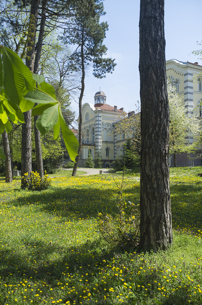
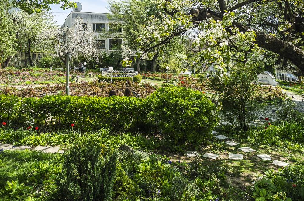
Garden of the Seminary of the Bulgarian Orthodox Church, Lozenets quarter, Sofia, Bulgaria, late-April, 2015. Fuji X100 with -1.4 wide angle converter. Click to Enlarge.

In a recent series of posts about Sofia, Bulgaria, I focused on the present-day appearances of the exteriors of Soviet-era, brutalist-style, prefabricated concrete-panel apartments block complexes built in the 1970s and 1980s, and on implications thereof re: issues of public and private space and of the nature of infrastructure.  However, Sofia is more than mere concrete.

Urban paradoxes

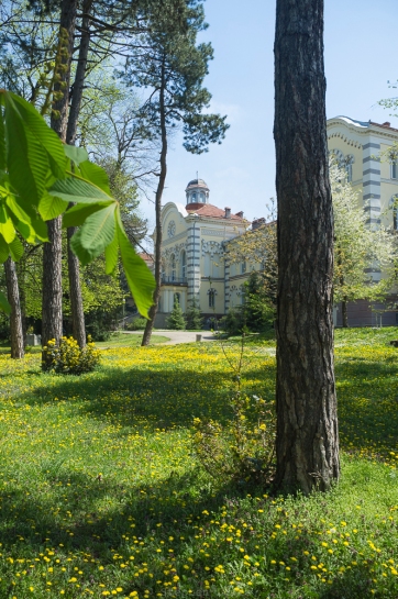
Sofia is a paradoxical city. Over the last century-and-a-quarter its population has grown by a factor of 100, from less that 20,000 to almost two million.  It is one of Europe’s most compact and densely populated cities — a potential advantage in terms of energy efficiency and non-automotive mobility, if and when properly capitalized upon.  Not least, Sofia is also one of Europe’s greenest cities — in terms of its tree-lined streets and unusually high ration of green-space to built-space.  Expansive parks, heavily-wooded and well-manicured, anchor the north, south, east, and west cardinal points of the city. Smaller parks dot the its and a greenbelt circumscribes its periphery.

Sofia’s parks were cornerstone features of a city plan drawn-up off-site in Berlin by the Nazi German architect Adolf Müssmann during the years of Bulgaria’s venal 1930s/1940s alliance with Hitler’s Germany.  The plan, by the way, was so foreign to the nature of Sofia and so imbued with Hitler’s visions for Berlin that it alienated Sofia’s otherwise quite pro-German municipal authorities and was in large part ignored.  After World War II, dedication to park space were the only elements of Müssmann’s concept that the newly-installed Communist regime retained in Sofia’s first post-war city plan drawn up in 1948. In the decades since the fall of Communism in 1989, shady property and real estate development deals have eaten away at the edges of Sofia’s once-ample green-space.  More recently, however, the green-space that remains appears, year by year, to be better and better maintained and more fully utilized.

Cultic gardens

Pictured above and below are two of Sofia’s smaller parks.  Both are the creations of religious traditions that emerged from the late-nineteenth scramble to create, shape, and give legitimacy to a Bulgarian national identity and to create new, vernacular-language, and supposedly indigenous spiritual spaces as alternatives to the once-ubiquitous power of the Greek Orthodox Patriarchate in what is now Bulgaria.

Seminary …

In the photo above: The garden of the Theological Seminary of the Bulgarian Orthodox Church. The autocephalic Bulgarian church was reconstituted in 1870 by a firman (writ) of the Ottoman Sultan Abdul Hamid II, in part as a concession to Bulgarian aspirations for political, cultural, religious, and linguistic autonomy.

The clerical buildings in the background of the photo tell a story of their own.  They were designed is what is retrospectively called the “Bulgarian National Style” — actually an  eclectic amalgam of Moorish Revival, Secessionist, neo-Baroque ,Jugendstil, and supposedly neo-Byzantine elements characteristic of the work of Friedrich Grünanger, an Austrian-Hungarian architect who spent the bulk of his career in Sofia and who designed a number of the city’s iconic structures including, in addition to the Seminary, the city’s central bath house and what is now Sofia’s one remaining synagogue.

The supposedly neo-Byzantine elements that gave  facades of Grünanger’s edifices their ostensible “Bulgarian National” character are horizontal courses of glazed-tile-work meant to simulate horizontal courses of brick interspersed between and cushioning courses of stone, a structural and decorative feature that was actually a signature, not of Byzantine architecture. but of the architecture of the Ottoman Turks, the non-Christian, “foreign” tradition that the Bulgarian National Style was meant to supplant and to obliterate from memory.

Grave of a mystic …

In the photo below: The carefully tended garden surrounding the grave of the late-19th/early-20th-century Bulgarian religious syncretist and mystic visionary, Peter Deunov.  Deunov, a son of one of the first clerics of the reconstituted Bulgarian Orthodox Church, studied at a Methodist seminary in the United States but, following his return to Bulgaria did not enter the ministry.  Instead, he founded a nature-oriented spiritual movement of his own, one that remains active and vibrant to the present day.  Deunov’s journey from belief to belief was not atypical of the experimental searching for new religious and political identities characteristic of urban Bulgarians of his generation. Izgrev (tr. “The Dawn”), the suburban neighborhood surrounding the garden, was founded as a colony by Deunov and his disciples in the early decades of the twentieth century.  The Deunov garden is one of the lushest, well kept, and peaceful green spots in Sofia — this the result of the voluntarism and sense of community of those who maintain it. May it remain that way.

Garden of the followers of Deunov, Izgrev quarter, Sofia, Bulgaria, late April, 2015. Fuji X100 with -1.4 wide angle converter. Click to Enlarge.

Garden of the followers of syncretic mystic Peter Deunov, Izgrev quarter, Sofia, Bulgaria, late-April, 2015.  At the center, Deunov’s grave. Fuji X100 with -1.4 wide angle converter. Click to Enlarge.