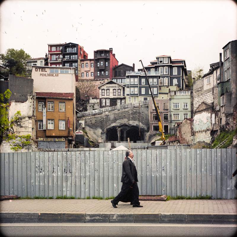
Istanbul, from Piyale Paşa Bulvari across from the Perpa wholesale complex upwards to Bomonti, 2012. Fuji X100. Click on image to enlarge.
As the summer temperatures rises, a few images of snow-dusted city-scapes that hint at the dynamics of a city …
Unlike my native New York, which — despite falling victim to a recent epidemic of new high-rise apartment and office towers geared to the profits of real estate developers and the prerogatives of the well-heeled, many of them part-time residents — remains a city of mostly late-19th- and early-20th-century brick structures, Istanbul, even with its plethora of centuries-old religious and secular monuments, is, in no small part, a city of concrete low-rise buildings and, more recently, of skyscrapers, shopping malls, and gated residential “communities.”
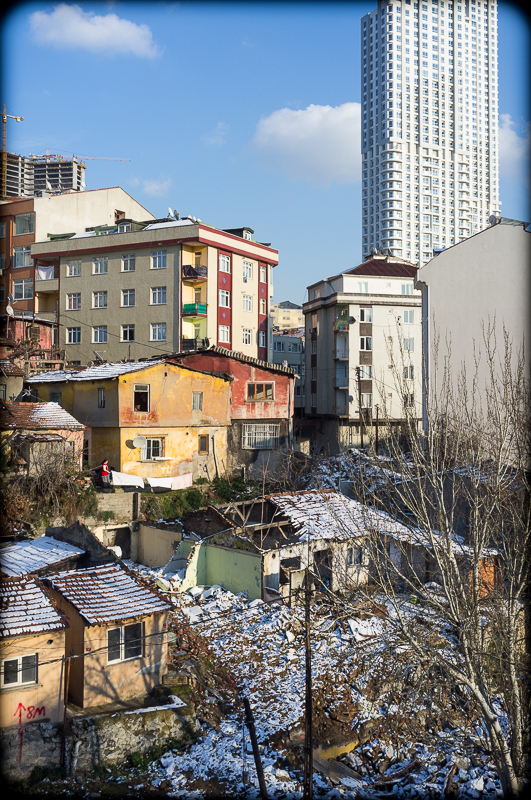
The views captured in the first and second photos in this post were taken from a one-time river valley, now the site of a multl-lane traffic thoroughfare, looking upward toward the neighborhood of Bomonti. The photos portray in miniature some of the features and processes that shape and call into question the futures of Istanbul and cities like it. Both photos captures Istanbul’s geography of heights and river valleys, with the more desirable locations on top and the least desirable at the bottom (this rooted in “ür”- concerns of rain- and waste-water drainage, air circulation, security, and symbolism of dominance), with gentrification occurring literally from the top down.
“Landed-By-Night”
In the bottom halves of the photos are one- and two-story illegally-built squatters’ dwellings, in Turkish geçekondu, “landed-by-night,” in recognition of the regulations- and authorities-defying overnight speed and covertness with which they were built. Beginning a half-century ago, during a peak in population growth when housing was scarce and expensive, Geçekondu arose in Istanbul’s vacant lots and least desirable slopes as a grass-roots means of sheltering waves of poorer new arrivals to the city.
Above the geçekondu, sited seemingly at random, are multistory cooperative and rental apartments built on the footprints of razed geçekondu — their sites amassed through buy-outs of squatters’-rights land titles ultimately granted to geçekondu occupants in exchange for apartment units in buildings constructed on the footprints of their one-time illegal dwellings.
At the tops of the two photos are high-rises of skyscraper proportions. The upper left of the photo above reveals an office complex still under construction at the time (note: these photos were taken in 2012. The same photo taken again today would contain ever more high-rises in its upper reaches). At the upper right of both photos, approaching completion, is the front-most of two adjacent twin “luxury” apartment towers with the unappetizing and dehumanizing, deadpan name of “Ant Hill Towers.” Because they are built on a downward slope, the twin high-rises of Ant Hill Towers are barely seem from the older, predominantly middle- and upper-scale neighborhoods above and also from along the Bosporus. From Istanbul’s historic peninsula, however, Ant Hill Towers are a perpetual presence that overwhelms the skyline.

Skyscrapers, Economies, Politics
Construction of high-rise office and apartment buildings has been a driver of the Turkish economy and a lucrative boondoggle for supporters of Turkey’s Prime Minister and his party and, as recent scandals alleged, maybe even for the Prime Minister himself. Through the filters of the cast of characters of my native New York, I sometimes see the Turkish Prime Minister as a cross between Tammany Hall’s Carmine De Sapio and ex-Mayors Rudolf Guliani and Michael Bloomberg (minus the latter’s bicycle lanes and bicycle rental programs and admittedly worthy tree-planting): i.e. cronyism plus misanthropy plus out-and-out pandering to the political and fund-raising support of real estate and construction interests.
Impacts of “Twin Towers” and the Labile Value of Views
Viewing Ant Hill Towers from a New York perspective also brings to mind … the Twin Towers of the belated World Trade Center — not from the perspective of the murderous destruction of the latter but from that of its conception and inception. Peel away the undeniable tragedy of the attack on the World Trade Center and the present-day cheesiness and carnival of “9/11” museums and memorials, and one recalls New York’s World Trade Center as it was greeted upon its completion back in the 1960s: i.e. as a twin eyesore, an economic white-elephant that would take years to achieve a base-level of occupancy, and a burden upon the city’s infrastructure (water and sewage system, subway capacity, etc.).
It is my not-too-uneducated guess that Ant Hill Towers, not unlike the World Trade Center, was designed and built as a structure in and of itself and not as part of a city, as a vertical suburb set in the urban core. I also assume that little if any attention was given to its effects on water/waste-water or power grids, nor to resulting surface water run-off, traffic congestion, pedestrian flows, or impacts on adjacent neighborhoods, let only on the city’s aesthetics. What was attended to, however, was the profit potential of building on under-utilized, centrally-located land and the marketing of princely ownership of views. Views, however, can be ephemeral and short-lived . The more structures that rise to exploit them, the more that views become obstructed and have their value undermined. Given time and the mushrooming of their like, views from mundane high-rises soon become views of other mundane high-rises, unwelcome mirrors rather than princely expanses.
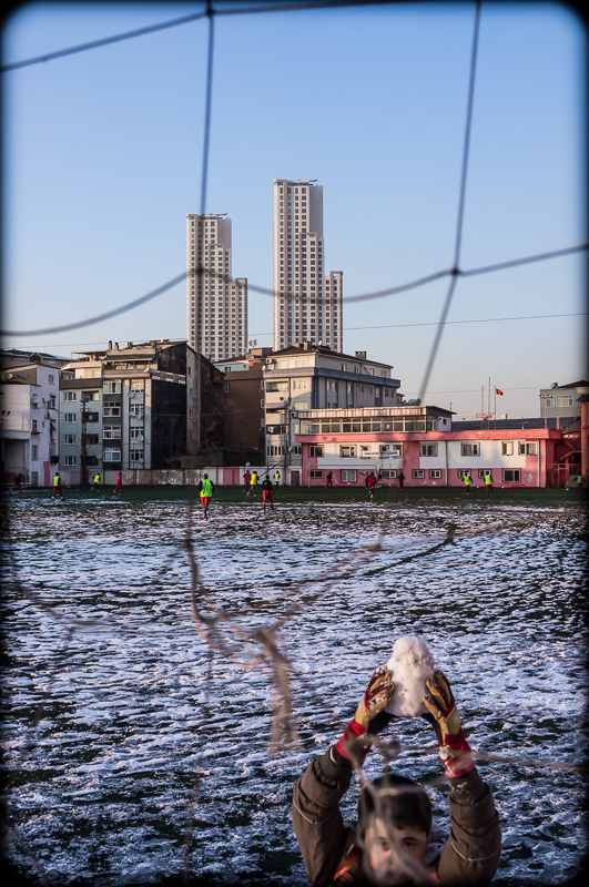
The upper stories of the Ant Hill Towers apartment complex, as seen from a football field at the heights of Feriköy, Istanbul, 2012. (Fuji X100). Click on image to enlarge.